

Hurricane Lee barreled westward with 155 mph winds on Friday, September 8th, after exploding in intensity on Thursday, doubling its wind speeds in just 24 hours.
But, hundreds of miles from land, the high-end Category 4 hurricane appeared to have peaked during its overnight climb to 165 mph. By Friday morning its winds had dropped slightly to 155 mph, though it was still an extremely powerful storm, making the most of a warm, open ocean and light winds. Millions were waiting to see what the dangerous storm would do in the days ahead.
High surf and life-threatening rip currents were expected to arrive along the islands in the northeastern Caribbean by Friday and remain through the weekend, the National Hurricane Center said. Then rough surf, rip currents, and hazardous conditions were forecast along much of the U.S. East Coast by Sunday evening.
The hurricane center’s official forecast track and most hurricane models predict Lee will continue to move west-northwestward into early next week and be somewhere northeast of the Turks and Caicos and eastern Bahamas on Tuesday.
Beyond that, it is “way too soon to know what level of impacts, if any, Lee might have along the U.S. East Coast, Atlantic Canada, or Bermuda late next week, particularly since the hurricane is expected to slow down considerably over the southwestern Atlantic,” the center’s Robbie Berg, a senior hurricane specialist, wrote in the 11 p.m. forecast discussion Thursday.
Lee was forecast to slow over the weekend as it meets a ridge that blocks its forward progress, Berg said.
Where is Hurricane Lee?
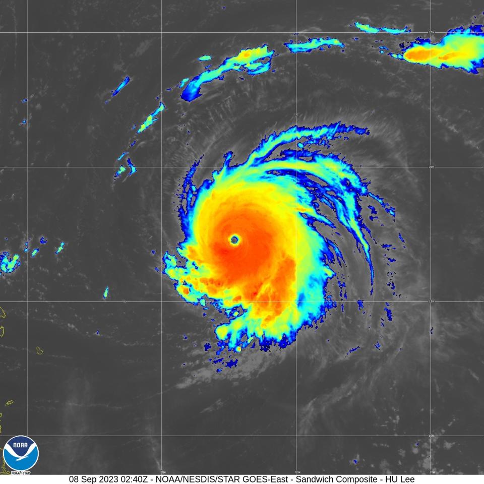
Powerful Hurricane Lee, strengthening to a Category 5 with 160 mph winds on Thursday, formed a wide clear eye in this composite satellite image provided by the National Oceanic and Atmospheric Administration. Lee is forecast to further intensify on Friday.
- At 11 a.m. Friday, Lee was 565 miles east of the northern Leeward Islands, moving west-northwest at 13 mph, the National Hurricane Center said.
- Satellite images showed a classic major hurricane, with a clear visible eye, and its central pressure had already begun to rise, up to 942 millibars from the earlier 926.
- Hurricane-force winds extended as far as 35 miles from the center of the storm, and tropical-storm-force winds extended up to 140 miles.
- The upper third of wave heights near the center of the storm have been averaging 45 to 50 feet, which means the highest waves could be double that, said Mike Brennan, director of the National Hurricane Center.

Hurricane Lee rapidly intensified to Category 5 status on Thursday, its peak sustained winds doubling in 24 hours, then began to weaken within hours. This forecast cone graphic from the National Hurricane Center shows the probable path of the center of the storm.
How high could Lee’s winds get?
Although initially forecast to increase to 180 mph winds, the official forecast calls for Lee to remain at 155 mph winds through tomorrow, then weaken gradually thereafter.
Overnight Thursday, the center said its new Hurricane Forecast and Analysis System had projected peak intensity of 195-207 mph winds, but the hurricane specialists kept with a more conservative forecast.
Only seven other hurricanes in the modern satellite era had reached a peak maximum intensity of 180 mph, said Phil Klotzbach, a researcher and seasonal hurricane outlook author at Colorado State University.
Lee was forecast to maintain winds of at least 150 mph through Tuesday.
Hurricane center’s forecast track for Lee
The official forecast track cone shows the most likely path of the center of the storm. It does not illustrate the full width of the storm or its potential impacts, and the center of the storm is likely to travel outside the cone up to 33% of the time.
Source: NOAA


